For all the grief Apple's gotten about the problems its new Apple Maps is causing for people trying to get somewhere, the app (now embedded in the new iOS6) includes remarkable satellite imagery. Like many of my fellow listeros, I've been using Google satellite images to scout trails and beach access up and down our coastlines. Apple Maps images are a big improvement over Google.
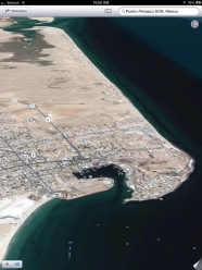
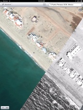
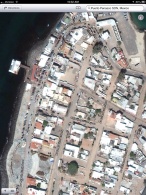
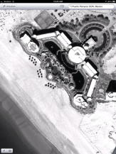
To achieve their exceptional resolution, Apple has made less-populated areas black-and-white. Below is the Mayan Palace in black-and-white, and the point at Playa Encanto where the Penasco-area satellite view switches from color to black-and-white. Also for fun, I attached the Malecon and a 3D view of Penasco from the west. On the morning the images were taken, you can see the pangas queuing up in the port, trawlers in the bay, a Jet Skier, and a Banana Boat guy.
So if you have a Mac, iPad, or iPhone, Apple Maps is a great resource for armchair Penasco flyovers.
For all the grief Apple's gotten about the problems its new Apple Maps is causing for people trying to get somewhere, the app (now embedded in the new iOS6) includes remarkable satellite imagery. Like many of my fellow listeros, I've been using Google satellite images to scout trails and beach access up and down our coastlines. Apple Maps images are a big improvement over Google.
To achieve their exceptional resolution, Apple has made less-populated areas black-and-white. Below is the Mayan Palace in black-and-white, and the point at Playa Encanto where the Penasco-area satellite view switches from color to black-and-white. Also for fun, I attached the Malecon and a 3D view of Penasco from the west. On the morning the images were taken, you can see the pangas queuing up in the port, trawlers in the bay, a Jet Skier, and a Banana Boat guy.
So if you have a Mac, iPad, or iPhone, Apple Maps is a great resource for armchair Penasco flyovers.
It is. But I think you can only get it by upgrading to iOS6. Apple replaced Google Maps as its built-in mapping app with its own Apple Maps with the iOS6 release, so once you upgrade your iPad, it will just be there on your home screen's first page.