I have guests that are coming from san diego and want to take the coastal highway but were told it was not safe. Has anyone driven it lately or have any input on it.
I drove from Yuma to PP through San Luis and El Golfo via the Coastal Road in May. The road was in excellent condition, had no problems, and did not feel unsafe at any point. I also have a close friend in San Diego who took the Coastal Road in mid September without incident. There is a military checkpoint between San Luis and El Golfo but it only effects northbound traffic.
Were the warnings your guest recieved specific or were they the standard/generic be afraid of Mexico right now? I am curious as I will be riding a motorcycle down the Coastal Road this weekend and would like to be aware of any new info on road conditions/safety concerns.
Thanks for the responses..greatly appreciated. Now, I have one more...is there a link that gives good directions from yuma to here on the coastal highway or does anyone have any. Also, is it bad driving through san luis? ( they asked me this and I have no clue.) One day will have to do the drive.
San Luis is pretty easy. you cross the border go 2 -3 blocks till you can make a left then go 2 - 3 blocks to another left then right onto hwy 2 then just follow the signs, ultra easy going in through SL but there is usually a wait on t he return trip I have a road log for the trip and if I can find it I will post it too!
If you want a scenic route comeing in from California you can go in at Mexicalli and take hwy 5 toward San Felipe to hwy 4 east toward Rito. south on Highway 3 to Elgolfo de Santa clara and then down the coastal highway to Penasco. you will go through the area where the earth quake was at victoria.
I had a friend from San Diego go home by way of the Highway and loved it. She did miss the turn off for Yuma claiming it was not marked well so she took the next crossing west of yuma.
A couple of things to think about. I normally cross at San Luis going down. When I cross the border I go east on highway 2 for about three miles and take the toll road, 8 dollars, fast and safe. Once you pass El Golfo beware of sand drifts on the road. On my return trips I find it faster to cross at Sonoyta because border wait times are much more predictable. I have been caught at the Federal check point and the border for hours.
would love some help - been searching on line with no luck at all for a detailed
map of the coastal highway route.
any and all segemnts, built or not.
I have come across some maps, but really the scale is so large there's no real detail.
I liked that stretch on the way to Puerto Lobos - very nice.
I'd like something where you can actually see each road you need to take from Rocky Point all the way to San Carlos.
thanks!
would love some help - been searching on line with no luck at all for a detailed
map of the coastal highway route.
any and all segemnts, built or not.
I have come across some maps, but really the scale is so large there's no real detail.
I liked that stretch on the way to Puerto Lobos - very nice.
I'd like something where you can actually see each road you need to take from Rocky Point all the way to San Carlos.
thanks!
Merry Christmas!!!
more eggnog ;)
It is in the works but probably wont be up till mid Jan to Feb early if it is ready! Pics and all!
I have guests that are coming from san diego and want to take the coastal highway but were told it was not safe. Has anyone driven it lately or have any input on it.
Thanks...
just drove that route last week, as we headed down to RP from PHX and couldn't cross the bridge in Sonoita. so, wee spent night in yuma, crossed at SL (way easy) took the new autopista and then the coastal road. i heard it was a new road, as none of my maps show it, but it didn't look all that new. but, easy to drive, little traffic, but wouldn't drive it at night due to sand/critters/curves and it would be completely pitch black.
I drive that route once a month and it saves me alot of time from California. I normally cross at Mexically and take Hwy 5 to 4 to 3. I travel it at night with no problem but what you have to watch out for is the sand drifts and fog. The fog is very scarry.
That fog creeping in on little cat's feet can be really weird. It rolls into the Mirador occasionally, usually in the early morning hours, and I can't see across the street. Driving in it would be a nightmare.
If you are coming from san diego would it be faster to cross at mexicali vs yuma? Also, is the directions above good for someone that has never driven it before? Thx
never crossed at mexicali, but found that most border crossings going INTO Mexico are quite speedy. have done Tijuana, San Luis and Sonoita all this summer, and no delays at all. coming back? bit of a different story so CA folks will have to weigh in as Sonoita two weeks ago was no waiting on a Tuesday....
Somewhere I saw detailed directions from San Diego to Penasco using the Coastal Highway but can't locate them now. Have friends coming this weekend - can anyone give detailed directions? Not sure if they have a GPS or not - if so are there any special codes they need to input? As you can tell, I've never used a GPS and no idea of how you get them to work ;)
Somewhere I saw detailed directions from San Diego to Penasco using the Coastal Highway but can't locate them now. Have friends coming this weekend - can anyone give detailed directions? Not sure if they have a GPS or not - if so are there any special codes they need to input? As you can tell, I've never used a GPS and no idea of how you get them to work ;)
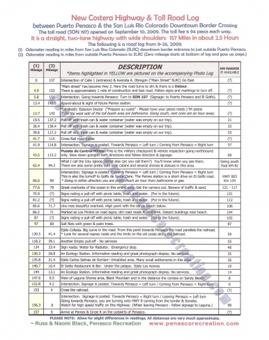
This is from San Luis crossing to Penasco. The only modification would be that you can come straight into Penasco now from the highway with having to go out to the round about on the main highway
between Puerto Penasco & the San Luis Rio Colorado Downtown Border Crossing
The toll road (SON 197) opened on September 10, 2009. The toll fee is 94 pesos each way.
It is a straight, two-lane highway with wide shoulders: 157 Miles in about 2.5 Hours
The following is a road log from 9-26, 2009.
(1) Odometer reading in miles from San Luis Rios Colorado (SLRC) downtown border entrance to just outside Puerto Penasco. (2)Odometer reading in miles from outside Puerto Penasco to SLRC (Zero mileage starts at bottom of log and goes up page.)
(1)
Mileage
(2)
Mileage
DESCRIPTION
*Items highlighted in YELLOW are pictured on the accompanying Photo Log
KM MARKER
IF AVAILABLE
0
157
Intersection of Calle 1 (entrance) & Avenida A. Obregon (“Main Street” SLRC) Go East
(?)
4.9
152
“Main street” has become Hwy 2. Here the road turns to dirt & there is a Detour. There is approximately 1 mile of construction and bad road. Follow signs and markings to turn off.
(?)
5.8
151
Intersection. Going towards Penasco: Turn to SON 197 (Signage: to Puerto Penasco and El Golfo).
(?)
13.4
143.5
Round-about & sight of future Pemex station.
(?)
13.7
143
Toll Booth: Estacion Doctor (“Prepare su cuota” - Please have your pesos ready.) 94 pesos * On the west side of the toll booth area are bathrooms. Going south, next ones are an hour away.
(?)
19.5
137.2
Pull off with trash can & water container (water was empty on our trip).
21
26.4
130.4
Pull off with trash can & water container (water was empty on our trip).
32
39.6
117.2
Pull off with trash can & water container (water was empty on our trip).
53
41.7
115
Cross Rail road tracks
(?)
41.9
114.8
Intersection. Signage is posted. Towards Penasco = Left turn / Coming from Penasco = Right turn
57
43.5
113.2
Puesto de Control Militar. This is the military checkpoint & vehicle inspection going northbound only. Slow down going in both directions and follow direction & signage.
60
This is part one. The cost has changed to 105 pesos per car each way or just over 8.00 usd
What I call the Icky Igloos. (What else can you call them?) You’ll know when you see them. There are also some pretty cute little cabins and several shrines & statues in this area.
Going south
Past KM 82
66.6
90
Intersection. Signage is posted. Towards Penasco = Left turn / Coming from Penasco = Right turn This is also the turnoff to Golfo de Santa Clara. The Pemex station is a short drive on El Golfo road. * Going in either direction you are pretty much an hour from bathrooms or gas.
HWY 003
Km 134
77.6
79
Great overlooks of the ocean in this entire area. Get the camera out. Beware of traffic & sand.
121 - 117
75.9
(?)
Signs noting a pull-off with picnic table, trash and water. (For in the future).
121
81.2
(?)
Signs noting a pull-off with picnic table, trash and water. (For in the future).
112
85.6
71.7
Uno mas beautiful overlook. High point with the sandy beach below.
106
86.2
71
Marked as Los Pinitos on road signs; dirt road reads ALMODOVA. Distant buildings near beach.
104
87
(?)
Signs noting a pull-off with picnic table, trash and water. (For in the future).
102
97
60
Salt flats with green & palm trees.
87
120.5
41.4
Ejido Collada. Big curve in the road. From this point towards Penasco the road parallels the railroad. * Look for several osprey nests and the birds on the old posts along the railroad.
59
118.2
39.1
Another Empty pull-off - No services
55
124
33.4
Sign reads: Water for Radiator. Emergency stop.
46
130.3
26.8
An Ecology Station. Informative reading and great photograph display. No services.
35
135.8
21.4
Ejido Carlos Salinas de Gortiari—Inhabited area. Many small settlements in this area.
26
140.7
16.4
El Solito Restaurant & Bar. Under the palapa. Ejido Los Aceves
19
144
13.1
An Ecology Station. Informative reading and great photograph display. No services.
14
147.6
9.5
View of Laguna Shores area, Black Mountain and in the distance the condos on Sandy Beach.
8
152.8
4.2
Intersection. Signage is posted. Towards Penasco = Left turn / Coming from Penasco = Right turn
0
153
4
Cross the railroad.
(?)
156.3
.6
Intersection. Signage is posted. Towards Penasco = Right turn / Leaving Penasco = Left turn Going towards Penasco, you are turning onto HWY 8 coming from the border & Sonoita. Watch for high speed traffic on this Highway. (When leaving Penasco - follow signage to Laguna.)
90
157
0
Arrive at Pemex & Circle K on the outskirts of Penasco.
(?)
This part 2 when entering Penasco from the west on the Coastal Highway you can drive straight into the resorts at Sandy Beach without going back out to highway 8
Thanks Russ....I'm sure that there are many out there without the navigational skills of Mexico Joe.....and will appreciate the "turn by turn" you've provided.
Thanks Russ....I'm sure that there are many out there without the navigational skills of Mexico Joe.....and will appreciate the "turn by turn" you've provided.
Like I said, it is so easy that if you cant read 3 signs the whole drive then you shouldn't be driving/operating heavy machinery. I got dizzy and almost puked reading Russ' trip log. 3 signs Joey, I could have gone from RP to SL when I was 11, no map. I had never done it till 3 weeks ago. Didnt have the luxury of a trip log when it was spur of the moment and it was so easy honestly, dont worry be happy and drive, GAS is on the right.
Russ's trip log was not meant to be a puke read, it was meant to be a guide for people who like to travel and not miss things that might be missed if you go along at 80 mph and are only interested in getting from point a to point b. The log was written several years ago and has served well as a guide for lots of folks venturing south and east from Cali to Penasco for the first time and has been lauded as the first one of its kind and not lacking in detail. So if you must puke please clean up after yourself and try not to get it on anybody else. Gracias. PS Gas is on the right........
Like I said, it is so easy that if you cant read 3 signs the whole drive then you shouldn't be driving/operating heavy machinery. I got dizzy and almost puked reading Russ' trip log. 3 signs Joey, I could have gone from RP to SL when I was 11, no map. I had never done it till 3 weeks ago. Didnt have the luxury of a trip log when it was spur of the moment and it was so easy honestly, dont worry be happy and drive, GAS is on the right.
Mexico Joe....at the risk of making this "another one of those threads" that we've been getting on the Forum lately, many of your posts make people puke too..... Russ provided a service posting the info.....it's a very easy drive getting to El Golfo, but if you take the time to check any of the mapping services, there are several routes you can take from there to the border (or the reverse direction)...so just maybe, Russ provided the most "efficient" route....but no, you have to go be a total ass with your post!
Russ's turn by turn directions are very helpful. Thx I may have to use the one day. It may even help those, whose Driving/Navagation skills are suspect anyway.
We have all seen them at one time, lately, alot!
Mexico Joe....at the risk of making this "another one of those threads" that we've been getting on the Forum lately, many of your posts make people puke too..... Russ provided a service posting the info.....it's a very easy drive getting to El Golfo, but if you take the time to check any of the mapping services, there are several routes you can take from there to the border (or the reverse direction)...so just maybe, Russ provided the most "efficient" route....but no, you have to go be a total ass with your post!
I disagree, I think posts like Russ' trip log make it seem like it is a tall task at hand which creates anxiety. Why do you think there is so many questions regarding the route? It's because people have made it sound like it is some cluster f#$K of a situation and that you need detailed trip routes with KM postings. It's the complete opposite. I wanted to express MY OPINION on this PUBLIC FORUM to let anyone that may have slight anxiety that a CHILD of 12 years old can do it without any help. Big highway signs that we are accustomed to in the states are on the highway in ENGLISH, what more could you need?! Im just trying to convey how easy it is.
Russ's turn by turn directions are very helpful. Thx I may have to use the one day. It may even help those, whose Driving/Navagation skills are suspect anyway.
We have all seen them at one time, lately, alot!
How are they very helpful if you havent driven the road yet?! lol In addition, you PRY wont have to use it one day because it is self explanatory. It was a nice gesture on Russ' part though.
I have another major website in rocky point, I had a client call me last week saying that he was "shaken down" by a local cop about two miles from border (heading north back into US). I get a lot of internet traffic regarding the coastal highway
(probably more than any other website) and I this is the only complaint I have received in years. Make sure you obey all traffic laws and have your proper paperwork. This was an elderly man, not a young college student. Good luck all. The road is actually a very nice road to drive on.
I have another major website in rocky point, I had a client call me last week saying that he was "shaken down" by a local cop about two miles from border (heading north back into US). I get a lot of internet traffic regarding the coastal highway
(probably more than any other website) and I this is the only complaint I have received in years. Make sure you obey all traffic laws and have your proper paperwork. This was an elderly man, not a young college student. Good luck all. The road is actually a very nice road to drive on.
Well, I would suggest that you do a search on google for the coastal highway and more than likely, the top site under most search terms is mine. I am not hear to promote the site, I was just assisting in info that I receive. No I don't receive 10,000 views a day or anything like it, but I am the #1 search term in most cases. Hint, was that review good enough for you.
Excuse me GOD, or so you think so. If this is a blog to not answer people's questions directly, then I suggest those with serious questions look else where.
If you (god) have condos that your trying to rent and any bad news effects your bottom line, then lie to people. You attack the message and the messenger. If you, like most ANYBODY else who has spent time in Mexico knows, cops have lied to get bribes for minor traffic offenses. That's why I always tell people to go to the police station with the cop, if you have done nothing wrong, Usually the policeman will end it there.
So if you want to attack those who attempt to help those asking serious questions, then you just give them your lying Rosie picture. As I said in the post, I have had little to no complaints about the highway, but they do exist and be forewarned. I have driven the highway many times and even off-roaded in the area a lot. However as you get closer to the border, trouble occurs occassionaly. To those who want answers, remember, GOD is only going to tell you his "for profit" prospective.
What?
Why not just post the site link? The coastal highway info people need to know should always begin with warnings about blowing sand build up on the road.Night driving isn't a great idea down south either as the men with guns land planes on it South of Lobos on occasion
p
Beachbob said:
Excuse me GOD, or so you think so. If this is a blog to not answer people's questions directly, then I suggest those with serious questions look else where.
If you (god) have condos that your trying to rent and any bad news effects your bottom line, then lie to people. You attack the message and the messenger. If you, like most ANYBODY else who has spent time in Mexico knows, cops have lied to get bribes for minor traffic offenses. That's why I always tell people to go to the police station with the cop, if you have done nothing wrong, Usually the policeman will end it there.
So if you want to attack those who attempt to help those asking serious questions, then you just give them your lying Rosie picture. As I said in the post, I have had little to no complaints about the highway, but they do exist and be forewarned. I have driven the highway many times and even off-roaded in the area a lot. However as you get closer to the border, trouble occurs occassionaly. To those who want answers, remember, GOD is only going to tell you his "for profit" prospective.
Well, I would suggest that you do a search on google for the coastal highway and more than likely, the top site under most search terms is mine. I am not hear to promote the site, I was just assisting in info that I receive. No I don't receive 10,000 views a day or anything like it, but I am the #1 search term in most cases. Hint, was that review good enough for you.
Your website is the most garbled bunch of sh!t you can put together at once. I would suggest using a professional web designer, someone who has more organizational skills. I've seen a lot of websites related to Rocky Point, never seen yours though. Looks like one of those websites from 2004 that hasn't been updated in 8 years, the kind that I AUTO disregard as useful! In regards to Jerry, he's not GOD but does have some pretty good weed and knows a thing or two about Mexico and in particular the coastal highway. When you have more than 23 posts come back and talk to us!
So Time wise- coming form San Diego using the coastal highway -- how long will it take to get to RP?
Going North from Rocky Point to San Luis Rio Colorado it took 2 hours and 20 minutes and that was with a northbound only checkpoint that took 20 minutes. I would say that you can get from SLRC to Rocky Point in 2hrs. 120 miles!
So Time wise- coming form San Diego using the coastal highway -- how long will it take to get to RP?
Find Obregon Ave, one street south of the border fence, take it east until you see the SIGNS IN ENGLISH DIRECTING YOU FURTHER, turn right, go till you see THE NEXT SIGN DIRECTING YOU FURTHER, go left AS THE SIGN DIRECTS YOU and BOOM 120 miles later you are in ROCKY POINT!
We've traveled from San Diego (north county) many times. With 1 gas and pee stop our typical trip is 5.5 hours. We usually cross at Calexico East. If you can handle the winding Hwy 2 at La Rumorosa, crossing at Tecate and taking Hwy 2 to Hwy 5 to Hwy 4 to Hwy 3 saves a 1/2 hour and 30 miles. Plus you don't have to encounter Mexicali and San Luis or the $9 toll. Named road directions are difficult to follow but if you go to one of the satellite map sites it is easy to pick out landmarks for your turns.
As far as times go
2 hours from San Diego to Calexico East X-ing
1.5 hours thru Mexicali and San Luis to toll booth on new toll road
2 hours from toll booth to RP
3/4 hour to get out of a ticket in El Golfo from passing police chief on highway
My new way is through Mexicalli. I take Hwy 5 toward San Felipe to Hwy 4 to the new coastal Hwy 3. Very nice ride. Just got my new Sentri pass can't wait to use it at the border coming home.