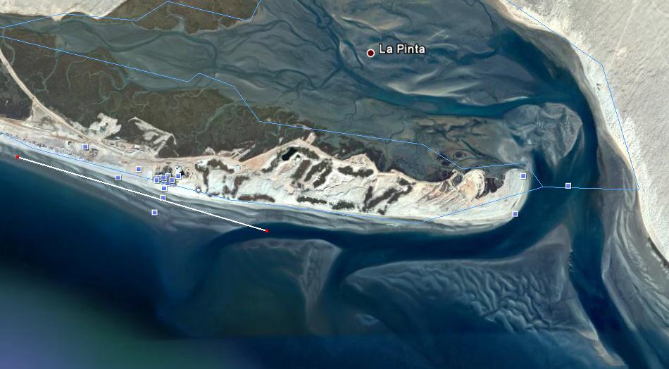
I'll be down fishing near La Pinta in a week. I'll be paddling from the place on the left, targeting the deeper water south of the Mayan Palace and into the estuary (about a 1.75 mile paddle).
Any suggestions or reports on this location?
The Mayan Palace is the place with all of the squares on it to the left of center. I'll be staying at the location at the very left of the picture. The La Pinta estuary is on the right side of the picture.
My plan is to troll jointed rebels and mirrolures, and maybe some krokodile spoons from the kayak as well as fish squid and shrimp from the beach in my spare time. There are some rocks near the beach house that are submerged at high tide.
We used to get Nacho, who lived in the house on the right side of the estuary, to take us out in his panga. We would fish off the bank on the left side where the channel rounds in from the Mayan, throwing Kastmasters towards the bank. We usually loaded up on nice fat corvina that run into La Pinta along that channel. Once you round that corner, the whole area you have marked to fish is good.
The line on the original picture goes from where I'm staying past the Mayan Palace. It measures 1.75 miles so I think it's correct??? I don't mind a good 2 mile paddle each way.
Are you saying where that line ends (the right side of the line) is not deep enough to fish?
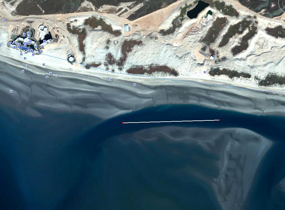
Here's a more close picture with the Maya on the left. The line in this one shows the area I was tentatively targeting.
Of course if the good fishing is farther south/southeast now then I'll have to get a ride. Anything more than a couple mile paddle to get to start of fishing is too much.
What the heck kind of lure is a 'yellow skirt' and where do I get one???
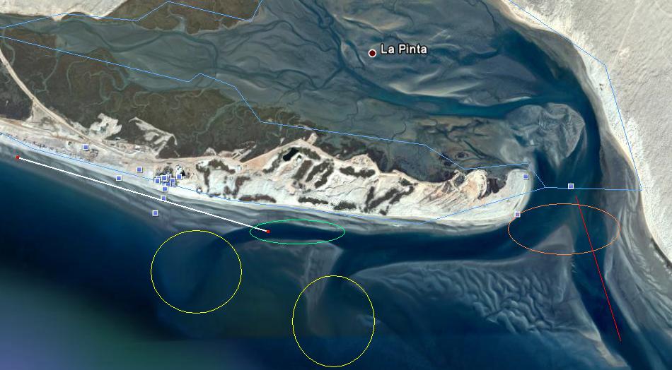
Thanks for the explanation. Here is a marked up photo.
I think you are saying that the channel with the red line is the only one that connects the estuary to the ocean at low tide and is therefore the main fish highway and I should target the area with the orange circle.
This means that the two areas with the yellow circles are exposed at low tide and those channels are cut off at that time so the area I was planning to target (green circle) is no good. I might even get stuck there and not be able to follow the white line home.
Thanks for the info, I'll just have to scout it out. It looks like there is a passable road almost to the far eastern end of the peninsula so I could drive there and launch the kayak. If not, I could drive way around and launch from the eastern side of the inlet. But I'm not bringing the 4x4 so that may be impossible.
I'd like to do a kayak sight-seeing trip into the estuary so driving was kind of in the cards anyway.
I was fishing worse locations (shallow water and sand at Playa Dorado) last spring and hooking up with nice corvina so anything nearer the estuary should be an improvement.
Thanks for all of the information.
I just checked and the dates I'll be there (10/5-10/8) the morning low tide is either at or above mean sea level. But it'll be interesting to see if the ~4 meter high tides is enough to fill the estuary.
Jmcd sez: "Thanks for the info, I'll just have to scout it out. It looks like there is a passable road almost to the far eastern end of the peninsula so I could drive there and launch the kayak. If not, I could drive way around and launch from the eastern side of the inlet. But I'm not bringing the 4x4 so that may be impossible"
What you have marked as the Golf House is actually the Construction Development Office. Yes there is a good road to that building and maybe beyond, but I seriously doubt that the Mayan security will permit you to enter and go out there to launch. Entrances to the Mayan are gated and guarded 24/7. I would not count on being able to drive out there. All access to the estuary on the Mayan side is controlled by them.
The road to La Pinta on the other side is fine for 2 WD. You only need 4wd if you need to drive on the beach to launch. It's only about 100 yards or less to the water from the parking area next to Gillespie's old hacienda. To get there go from where you are staying to the paved highway and turn right. Go past the Mayan entrance about 2 miles or so and watch for an abandoned house on the right side of the road and a very broad entrance road, take a right and in a mile or so you'll be at the Hacienda. There will probably be several panga's there with associated vehicles.
Also be sensitive to the tide flow. You may find it difficult to go against the tide as the flow can be quite strong.
Buen Suerte, maybe I'll see you out there. Maybe I'll sail the Ketch out for the day !!
the entrance to La Pinta is about the 32 t033 kilometerr sign. the road down to the old gillespie house is very passable with 2 wheel drive. the google earth photos were taken just about at low tide. if you go another kilo to kilo 34 you will be at the entrance to San Jorge. if you want to go in tell them you are going to see Becky at the trailer park. we are about 2 miles down the road toward the beach. we have been playing down there for 17 years.
the entrance to La Pinta is about the 32 t033 kilometerr sign. the road down to the old gillespie house is very passable with 2 wheel drive. the google earth photos were taken just about at low tide. if you go another kilo to kilo 34 you will be at the entrance to San Jorge. if you want to go in tell them you are going to see Becky at the trailer park. we are about 2 miles down the road toward the beach. we have been playing down there for 17 years.
The trailer park ought to get themselves a little tractor, and start launching boats down there!!! Make a few pesos! I don't have 4WD, but woud love to launch my jetskis down there....be closer to Bird Island....it is a long ride on skis from the harbor (done it before)....especially going back when the wind comes up and you can only plow ahead doing about 15mph!!!
Thansk Wahoo for the detailed markups on the map. And thanks for the directions and the password San Jorge George -- Now I know just where to go.
I'm so prepared, I'll probably get sick and miss the trip or something.
I'm taking the family and quads to La Pinta tomorrow for a day of relaxation. Don't think I'll throw in a pole. I plan to just kick back and have a couple beers. The wife and kids like shell hunting there. Anyone else want to come?
I just returned.
Sunday, Monday, and Wednesday were too choppy to fish.
Tuesday the water was like glass so I went over to La Pinta in the area labeled "Shore Launch" on Wahoo's marked up satellite photo.
There were a lot of Pangueros there and I was way out of place as the only Gringo there with my bright orange kayak. But every one was nice and didn't give the strange Americano any trouble.
I was there right about high tide (3pm) so I was afraid to head across the estuary or out to sea, fearing I might not be able to fight the outgoing tide coming back. I fished around the channel generally up-estuary (north) from the shore launch area.
I caught a couple of Corvina, both about 19 inches. Both on blue and silver rebel jointed minnows.
It was a hoot, but next time I hope to have more time and try for other species as well. Thanks for all the info.
I am headed to La Pinta in early June. I would be greatful if you could tell me what you learned last October. I am staying at the Mayan and am very interested in the mouth of the estuary and the estuary itself.
I am headed to La Pinta in early June. I would be greatful if you could tell me what you learned last October. I am staying at the Mayan and am very interested in the mouth of the estuary and the estuary itself.
Terry
Hi, I did go and launch from the area labeled "shore launch" on Wahoo's map earlier in the thread. It's on the opposite side of the estuary from the Mayan and an easy drive with 2-wheel drive. The area was heavily used by commercial fisherman but they didn't seem to mind me parking and launching there.
I didn't paddle all the way over to the Mayan side but stayed pretty close to that launch as it was my first trip and distances and currents can be deceiving. As reported above, I caught a couple of nice Corvina that afternoon in about an hour and a half on Rebel minnow lures at high tide. I probably could've caught more but I spent some time throwing some spoons over where I believed there to be a reef - with no luck.
The estuary is beautiful and a neat place to paddle. I plan on going back to the same place this June. If you're staying at the Mayan, you might consider launching from there if you can since there appears to be some deep water fairly close - but it may be too far, I forget. Rely on Wahoo's map (on page 1 of this thread) and advice. All the advice I got on this thread was good and reliable.
I messed around in those channels a few years ago. I saw some good sized fish I assumed were guitar fish scooting away from me. I also ran my boat aground a few times so I didn't go back. It did look interesting. It might be ok in a raft or kayak.